Wewelsfleth
Hafen bei wewelsfleth.

Beschreibung
Der kleine kommunale Yachthafen hat an der Aussenseite des Schwimmsteges 3m Wassertiefe.
NV. Hafenlotse
Es ist möglich bei der Werft zu tanken per Kanister dort ist eine Hafennahe Tankstelle ca 5-10 min den Deich entlang entfernt. Nur Kartenzahlung möglich.
Die Slipanlage ist nur bei Hochwasser zu verwenden. Sehr verschlickt und rutschig. Man benötigt zudem einen Schlüssel für die Kette vom hafenmeister.
Hafeninformation
Geldautomat
Öff. Verkehr
Du kannst mit der NV Charts App (Windows - iOS - Android - Mac OSX) Kommentare hinzufügen. Unter nvcharts.com/app kannst du die aktuelle Version installieren.
Passende NV Charts Seekarten für diesen Ort Durch einen Klick auf das Produkt gelangst du direkt in den Shop.

Orte in der Nähe
- Ankerplätze
- Geschäfte / Restaurants
Borsfleth Störloch
Hafen bei Borsfleth
1.39 km von hier entfernt
Beidenfleth
Hafen bei Beidenfleth
4.05 km von hier entfernt
Glückstadt Binnenhafen
Hafen bei Glückstadt
6.43 km von hier entfernt
Yachtwerft Glückstadt
Glückstadt - Außenhafen
6.45 km von hier entfernt
Stör - Langes Rack
6.62 km von hier entfernt
Schleuse Kasenort
Hafen bei Landrecht
7.73 km von hier entfernt

Stör - Werft Kolz
Ankerplatz bei Bahrenfleth
3.91 km von hier entfernt
Ankerplatz bei Glückstadt
6.47 km von hier entfernt
Ankerplatz bei Seestermühe
18.81 km von hier entfernt
Wendestelle "Klein Westerland" - NOK Liegestelle für Sportboote
Ankerplatz bei Hochdonn
22.36 km von hier entfernt
Ankerplatz bei Hetlingen
25.87 km von hier entfernt
Wedel Hafen
Ankerplatz bei Wedel (Altstadt)
35.02 km von hier entfernt
Wewelsfleth - "Nahkauf"
Einkaufen bei Wewelsfleth
0.42 km von hier entfernt
Bootsausrüstung Günter Klingbeil
Boot Reparatur & Yachtausrüstung bei Glückstadt
6.34 km von hier entfernt
Restaurant bei Wedel (Altstadt)
34.71 km von hier entfernt
Hamburger Yachthafen - Yachtprofi Tankstelle GmbH & Co. KG
Tankstelle bei Wedel (Altstadt)
35 km von hier entfernt
Yachtausrüstung bei Wedel (Schulau West)
35.39 km von hier entfernt
Wedel - "Elbesegel" Hauke Meyer
Segelmacherei bei Wedel (Schulau West)
35.42 km von hier entfernt
Der Segelmoker Inh Holger Tesch
Segelmacherei bei Cuxhafen
45.59 km von hier entfernt
Restaurant Costa Nova
Restaurant bei Cuxhafen
45.86 km von hier entfernt
Die Kleine Fischkiste Restaurant
45.87 km von hier entfernt
Restaurant am Pier Cuxhafen - Alte Liebe
45.92 km von hier entfernt
Maritime Technik Cuxhafen GmbH
Yachtausrüstung bei Cuxhafen
45.97 km von hier entfernt
Segelmacherei & Service Wittmaak
45.99 km von hier entfernt
Zugehörige Regionen
Dieser Ort ist in den folgenden Regionen des BoatView Hafenführers enthalten:
Diese Seite teilen
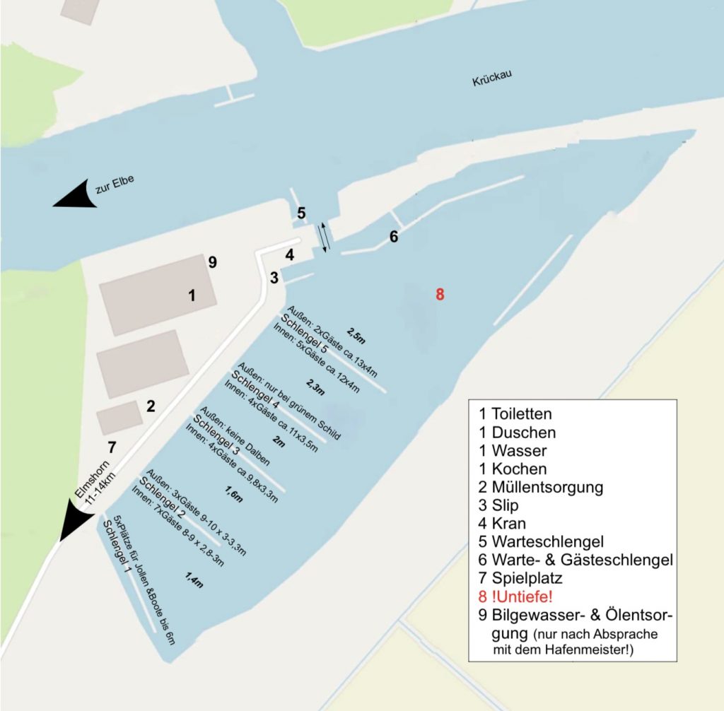
W.Y.K. Elmshorn
Wassersport- und yachthafenvereinigung krückaumündung e.v., herzlich willkommen im sportboothafen der w.y.k. elmshorn.
Seglern und Motorbootfahrern aller Altersgruppen bietet unsere Wassersport- und Yachthafenvereinigung Krückaumündung e.V. ein attraktives Zuhause mit angenehmer Gemeinschaft, naturnaher Umgebung und der Elbe als erstklassigem Segelrevier.
Der Sportboothafen an der Krückaumündung
In idyllischer Landschaft, ideal geschützt und direkt an der Krückaumündung zur Elbe (Tonne PN 8) liegt unser Sportboothafen.
Gleich an Steuerbord hinter dem Krückausperrwerk gelegen, verfügt der Hafen über Schwimmstege mit Heckpfählen. Der Hafen ist ein Dockhafen, ein Sperrtor hält das Wasser auf Tiefe, sodass Sportboote (max. 2,70 Tiefgang) nicht trockenfallen oder einschlicken.
Der Hafen ist ca. 2 Stunden vor bis kurz nach Hochwasser erreichbar, das Sperrtor öffnet bei ca 600cm Pegelstand Glückstadt (PNP).
Für weitere Informationen, bitte anklicken:
Ansteuerung , Pegelstand Glückstadt
Wewelsfleth: The town name may combine to the Saxonian family name Wibil plus "fleth," a natural watercourse in a marsh. It is the smallest in size, but highest in population, of the Wilstermarsch towns. Ship building traces to 1740 when ship carpenter Siemen Falck started a ship repair firm. The coat of arms -- with a farmhouse and ship under sail -- symbolizes the town's two economic pillars. See mayor and special events. [ Link is to a Babel Fish translation. Note that the Stör River translates as "those disturb." Click for German origina l].
Wewelsfleth entry in Wikipedia, describes geography, culture, politics and more [in German]. Ship-building is historically important.
History, size, and industry of Wewelsfleth are described in English on a page in the Blasorchester Wewelsfleth Web site [in German] . A blasorchester is a "blowing" or primarily brass orchestra.
Wewelsfleth inhabitants [pdf format] were traditionally employed in fishing, farming and shipbuilding, according to an article on the laying of the keel of the new vessel "Euro Solid" in the main shipyard there.
Wewelsfleth locator map, postal zip code, official license code letters, nearby towns, links plus Wewelsfleth map showing its relationship with Krempe, Borsfleth, more, plus telephone book online search tool
Wewelsfleth is on the Stör River, the 3rd-longest in Schleswig-Holstein . Discover the state's geography, with marshland, moorland or geest, and hill country.
An in-depth look at the history, culture and maps of Schleswig-Holstein .
L ocations & Maps [ Top ]
Photo map shows Wewelsfleth on the Stör, with Uhrendorf up river. Use down arrow to see Borsfleth, then Glückstadt to the south.
Map showing Wewelsfleth in relation to the Stör and Elbe rivers, Borsfleth, Itzehoe, Glückstadt, Wilster, more
Towns north of Glückstadt -- with distances -- include Beidenfleth , Borsfleth , Dammfleth , Hollerwettern , Uhrendorf , Wewelsfleth , and south of Gluckstadt Deichreihe near Kollmar . And many more.
Interactive satellite map with Glückstadt pinpointed on the Elbe River, other towns to the north such as Ivenfleth, Borsfleth, Wewelsfleth , Uhrendorf, Krempe, more. Agricultural fields are visible.
Maps for Wewelsfleth and for towns and villages within 10 miles in any direction. Choose M for Mapquest, G for Google Maps and more.
Map of the mouth of the Elbe River up to Hamburg, showing Glückstadt, Wewelsfleth, Itzehoe, Wilster, and Heide in Dithmarschen at the top, and more 1910 Baedeker maps of Northern Germany
Map of the Elbe River , highlighted in yellow, running from the Czech Republic across Germany past Hamburg to the North Sea, and a map of the Elbe River , showing land elevations on its course.
Map of the Elbe River , North Sea to Hamburg, showing 13 nautical chart segments. Enlarged map has tributaries Stör, Krückau, Pinnau
Maps of Schleswig-Holstein south of Denmark, with North Sea west, Baltic Sea east, and Hamburg south on the Elbe River. Click to enlarge and see the Stör River north of Gluckstadt. View a Schleswig-Holstein interactive map with Gluckstadt and Wewelsfleth near the bottom.
Wilstermarsch - a photogallery showing 24 views between Glückstadt and Brunsbuettel with windmills, churches, marsh with sheep, and more .
Wilster , its old town hall built in 1585, is at the heart of Wilstermarsch. Thatch-roofed cottages, lush pastures and friendly people are typical.
Maps of the Wilstermarsch and Krempermarsch regions south of Southern Dithmarschen and north of the Elbe River, and of communities including Gluckstadt, Borsfleth and Brunsbuettel. Unnamed, Wewelsfeth is the town area shown just north of the confluence of Stör and Elbe rivers.
The Stör River , just 54 miles [87 km] long, begins east of Neumünster . It flows through Itzehoe as shown on this map , also through Wewelsfleth.
Winding Stör River and terrain near Itzehoe, and a tour along the river in 22 photographs from Arpsdorf at km14 through Kellinghusen km 32, Itzehoe km 53, Beidenfleth km 69 to storm barrier km 80 and the Elbe.
Stör River is the the largest right tributary of the Elbe River in Schleswig- Holstein. See picture and interactive map of the river and tributaries such as the Krempau that flows through Borsfleth and the Wilsterau that flows through Wilster among them [in German] .
Stör River tributaries , pictured, range from Der Aalbek to Die Krempau that flows through Borsfleth to Die Schwale to Die Wilsterau . See also the fish types in the Stör [in German] .
Stör Storm Surge Barrier was inaugurated in 1975 to protect the Stör River interior region during high water, with photos. Another view plus one of the moveable bridge that is part of the barrier.
Stör Hole Borsfleth Yacht Club, with a view of the water, the flat terrain, narrow strip fields, and the Stör River and surge barrier, in 5 photos.
Stör River once had rope-based ferries or Seilfähre, but now just one, says this profile of Beidenfleth, near Wewelsfleth. There Störkringel, an area favorite, is still baked, a hard, pretzel-shaped pastry . Learn more about Beidenfleth [in German] and Beidenfleth [translated] .
Die Seilfähre or ferry in Wewelsfleth operated until 1976, just after the opening of the storm surge barrier and its bridge.
Panoramas: Wintergarten and Winter StraBe near Wewelsfleth
Picture of Itzehoe with its historic St. Laurentii-Kirche or church and half-timber buildings plus modern structures. More pictures for Itzehoe , which is the county seat of Steinburg
Pictures and history for the Steinburg district include the town Krempe , the town Wilster , Glückstadt , and a water-scooping-mill in Honigfleth .
Glückstadt: click British flag for info in English, photos of town, river
Pictures of Wilstermarsch: Elbe and Stör rivers, windmills and historic structures such as Wewelsfleth's Die Fahrradscheune [Bicycle Barn]. See also the Wilster old town hall.
Photos of the Elbe at Kollmar south of Gluckstadt and near Deichreihe provide a vivid sense of the landscape. Select the link Bildergalerie for panoramas of the region and photogalleries for each month.
Maritime Elbe River area tours include one starting at Ivenfleth, including Borsfleth [See Der Gemüsetörn, tour 14], showing a photo of Borsfleth church and an historic half-timbered house
Lighthouses of the Elbe and Hamburg, including those of Gluckstadt, Wewelsfleth, more, with photos including lighthouses and landscape.
Photo of the Kiel Canal or the North Sea-Baltic Sea Canal, with the Elbe River in the background and showing the countryside near Brunsbüttel, not far from Wewelsfleth. Learn more about the Kiel Canal .
The lower Elbe River landscape shows its maritime heritage, with ships, old harbors, warehouses, more. A look at the Elbe River .
Photo of icepack on the Elbe River near Hamburg, January 2006, and a sunset at Hamburg Harbour and photos of Elbe River in Hamburg
Maps, weather -- including temperature, cloud cover and precipitation -- plus nearby communities and airports for Wewelsfleth
Weather in Wewelsfleth, from Yahoo, and Wewelsfleth weather
C ulture, School, Language & Church [ Top ]
Grundschule Wewelsfleth , the town's primary school with 130 pupils and the special project featuring Common School Magazine
Trinitatis Kirke or Trinity Church in Wewelsfleth, with photographs of the lovely interior and the exterior. It was built in 1503 A.D. Click the link Termine at left to see dates of church and community events and contact names for organizations that partner with the church on events. [ Babel Fish translation. See German origina l], Trinitatis Kirke home page.
Pictures of 1698 Alfred-Döblin-Haus in Wewelsfleth bought by Günter Grass, as well as the Gluckstadt harbor, typical marsh region houses, other images from the Gluckstadt area. View of Alfred-Döblin-Haus .
Schleswig-Holstein has the North-European tradition of adding -sen or -so(h)n to a father's name to make surnames: Claussen, Petersohn, etc.
Cultural monuments in Steinburg from Honigfleth to Beidenfleth to Glückstadt to Wewelsfleth: city halls, churches, farmhouses, barns, windmills, more [in German]. The house Günter Grass bought in 1970 was from 1859 the home of the Junge family, Wewelsleth shipbuilders.
Typical buildings and landscape in or near Brokdorf, Glückstadt and Wewelsfleth are pictured [scroll down]. In addition, two varieties of the typical massive farmsteads roofed with reeds [see Section 3.2 here ] are known as the Barghus, for example the Haubarg in Eiderstedt, and the Husmannshus, such as this one in Dammfleth, near Wewelsfleth.
Pictures and diagrams of the traditional hallenhaus , the north German farmstead building encompassing the family home, stalls for cows and horses, and the central hall for threshing or other activities. Variations were known in the region from Holland and Holstein to Prussia.
Das niederdeutsches Hallenhaus had storage for hay and straw up under the roof and stalls for cows along the edge. Eventurally the dwelling space for people was divided by walls from the barn area.
The 1683 school building in Borsfleth [in German] also shows the area's typical building style. Borsfleth is 1.8 miles [2.9 km] from Wewelsfleth, across the Stör River as seen on this map . More pictures of Borsfleth with its traditional half-timbered houses, streets.
SPD Wewelsfleth has a welcome from the burgomeister or mayor with town details, the local council and more. SPD is the social- democratic party of Germany. [ Babel Fish translation. See German origina l]
Volunteer Fire Brigade in Wewelsfleth, with photos
Die Fahrradscheune or the Bicycle Barn in Wewelsfleth -- a beautiful barn with historic bicycles such as a velocipede (1870) and high wheeler (1880). Pictures including one of the barn with bicycles, and a photo of one of the historic bicycles . [All sites in German] .
Drachenfeste Wewelsfleth , or Kite Fest, and more photos .
Stör River news shows the Störschipperfest in 2007 with traditional river transport ships or ewers, the moving of the ship or Störewer "Hermann," the 2006 launch of the new rope-ferry Else at Beidenfleth and flooding on the Stör River near Kellinghusen in 2004.
Weinkontor or wine bar in the heart of Wewelsfleth, with directions from Hamburg or Husum [in German].
Land Hotel Lüders , Wewelsfleth, is located in a specialized hall typical for the Wilstermarsch and its restaurant offers regional food specialties. Another view plus Cafe Uhrendorf [in German].
A griculture, Food & Industry [ Top ]
History of Agriculture includes the history of farming in Germany and the influence of Holland on north German agriculture and dairy farming, especially after 1550. Britannica, 104 pages.
In the 1600s, Anabaptists from the Low Countries are said to have introduced dairy farming in southwest Holstein near Wewelsfleth . The famous black and white dairy cow known as the Holstein or the Holstein-Friesian, originated in northern areas of the Netherlands .
Gardens of village families included vegetables, fruits, herbs and on occasion flowers. In northern Europe as early as 1500, foods grown included kale and cabbage , peas, leeks, onions, garlic, sage and other herbs, and strawberries, apples, cherries and plums.
Potatoes were first grown in Germany in 1620. Widespread cultivation only occurred by the late 1700s.
Food dishes of Schleswig-Holstein are shaped by fisheries and the dairy industry. A typical dish is a soup of kale with sausages and potatoes. Others: Old German potato soup , kale and pork chops , more .
Schleswig-Holstein has a tourists' cheese route for sampling.
German cuisine is outlined, with regional specialties given such as aalsuppe and labskaus from the Hamburg area
Pork and beer , favored by ancient Gauls, are still important in German cuisine, which is also influenced by religion and region, the south being typically Catholic, the north Protestant.
The J. Junge Shipyard of Wewelsfleth once built small ships, including the flat- bottomed Anna constructed in 1910 to transport foodstuffs, peat and coal on the Lower Elbe. Anna [in German] with photo.
Johanne , formerly called Meteor, and the Berta are other river vessels or ewers built at the J. Junge shipyard, Wewelsfleth, 1905 and 1910. As early as 1875, the Johann Junge shipyard was the first to build a new model of ewer for use as fishing ships [in German] . See photos of models of these Besanewers from the Johann Junge shipyard.
Ship Hermann built in 1905 at shipyard of Claus Witt, Wewelsfleth, one of some 1,000 ewers or river vessels that carried goods to Hamburg.
A profile of Peters Schiffbau notes that in its early days it built wooden vessels that were herring luggers, pilot boats, galleasses [fighting ships], and kuffs [two–masted freight sailing vessels].
An interview with a worker at the Wewelsfleth Dockyard, by students
A few of the many vessels built at the Peters shipyard in Wewelsfleth are: · Cuxhaven , pilot schooner built in 1901, now the Atalanta, also here · Warturm , 1968, anchor-handling tug supplier · Sinbad , 1981, and Polarwind , 1983, cargo vessel; Elisia , 1984, multipurpose, and container vessels Freesia, 1983, and Tertia, 1985, and Ida , 1986, shown discharging timber. · Cargo ships Fri Sun, 1980; Fri Sky, 1981; and Fri Star, 1981 · Fehn Moon , 1990; 23 more hard-working ships; Patriot , 1994; and Frieda , 1995
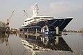
Kusch Yachts , founded by Claus Kusch, has been building mega yachts in Wewelsfleth for 25 years. Jan C. Wolf worked awhile.
P eople & Genealogy [ Top ]
Christian Stengel , full name Otto Christian Stengel , was born March 3, 1795, in Wewelsfleth. He had a 60-year career as doctor to the mining district of Røros, Norway. He has descendants in America.
Carsten Conrad Kohrs was born in 1835 in Wewelsfleth, a fishing village in Holstein and left in 1850 for a life of adventure. He became a U.S. citizen in 1857, built a cattle empire and was Montana's Cattle King. Tthe National Park Service today runs the Grant-Kohrs ranch near Deer Lodge, Montana, as a National Historic Site Johann H. L. Kohrs , his brother, settled in Iowa and ran a pork packing business.
Lutheran Church parish records for southern Schleswig-Holstein, noting that Wewelsfleth records go back to 1650.
Population of Wewelsfleth and other towns north of the Elbe River, in the left column, with small number and percentage who are Catholic
Wewelsfleth page in We Relate Genealogy site, to be developed
Schleswig-Holstein Genealogy including a large emigrant database, a timeline of the complex history of this area fought over by Denmark and Germany, maps, towns, names, more
Schleswig-Holstein Genealogy including those who emigrated abroad to America and elsewhere
New Holstein: this town in Calumet County, Wisconsin , was settled by Germans from Schleswig-Holstein, but especially locations in Holstein. Among them was Cecilia Tonner Boie, born December 3, 1830, in Wewelsfleth, the daughter of Claus Tonner and Margaretha Suhr who married there on July 7, 1828. All of their children emigrated to America, and Claus himself came in 1874.

Wewelsfleth Wewelsfleth, Steinburg, Schleswig, Schleswig-Holstein, Preussen
Entry Map Ecclesiastical Related Feedback

Show previous and next entry View entry on PDF of the original page

Aussendeich 4)
Hollerwettern
Kleinwisch 3)
Landscheide 4)
Uhrendorf 1)
*Indirectly referenced
The Catholic Parish is Glückstadt
The Protestant Parish is Wewelsfleth
*Source: Family Search
The list below are those places from the Meyers Gazetteer that are nearby to Wewelsfleth (which may include itself) and are listed as containing a Catholic Church or Parish, a Protestant Church or Parish, a Synagogue, or Other Church.
If you see something incorrect, please let us know! Unfortunately, we are not able to provide information on specific families or names at any place.
North America
South america, wewelsfleth map — satellite images of wewelsfleth, detailed map of wewelsfleth and near places.
Do you like this map? Link to it or recommend it !
Register at Wewelsfleth or add new placemark for Wewelsfleth . Get your personal map homepage and much more for free.
Wewelsfleth hotel reservations
Book hotel in wewelsfleth online and save money.
- Wewelsfleth hotels »
- Browse & Book hotels in Germany »
- Wewelsfleth hotels – sortable list of all Wewelsfleth hotels »
Wewelsfleth hotels: low rates, no booking fees, no cancellation fees.
At Maplandia.com you won't be charged any booking fees, cancellation fees, or administration fees – the reservation service is free of charge . The reservation system is secure and your personal information and credit card is encrypted.
Wewelsfleth hotels map
The location of each Wewelsfleth hotel listed is shown on the detailed zoomable map. Moreover, Wewelsfleth hotel map is available where all hotels in Wewelsfleth are marked. You can easily choose your hotel by location.
Wewelsfleth hotel reviews
Many photos and unbiased Wewelsfleth hotel reviews written by real guests are provided to help you make your booking decision.
Wewelsfleth hotel deals
Luxury hotels (including 5 star hotels and 4 star hotels) and cheap Wewelsfleth hotels (with best discount rates and up-to-date hotel deals ) are both available in separate lists. Always bear in mind that with Maplandia.com and Booking.com the best price is guaranteed!
Hotels nearest to the centre of Wewelsfleth
- Ferienzimmer Bärbel Mehlert (at Schulstr. 4 in Wewelsfleth)
- Greenline Hotel Busch ** (in Wilster , distanced approximately 8.3 km)
- Gästehaus Elbdeich *** (in Gluckstadt , distanced approximately 9.9 km)
- Mercure Hotel Itzehoe Klosterforst **** (in Itzehoe , distanced approximately 12 km)
- Gut-Kleve ** (in Kleve , distanced approximately 13 km)
- Gästehaus Sieb *** (in Wischhafen , distanced approximately 14 km)
- Hotel Royal *** (in Elmshorn , distanced approximately 19 km)
- more Wewelsfleth hotels »
Wewelsfleth car rental
Compare wewelsfleth car rental offers of 500+ suppliers, car hire wewelsfleth and neighbourhood.
Car rental offices nearest to Wewelsfleth the city centre. Compare Wewelsfleth car rental offers by various suppliers.
- Itzehoe car rental (distanced approximately 12 km)
- Elmshorn car rental (distanced approximately 23 km)
- Stade car rental (distanced approximately 30 km)
- Stade-Dollern car rental (distanced approximately 36 km)
- Wedel car rental (distanced approximately 37 km)
- more offers and Wewelsfleth car hiring guide »
Flights from airports close to Wewelsfleth
Search and compare flights.
- Flights to nearby airports to Wewelsfleth »
- Overview of flights to and from Germany »
- Flights search »
Compare prices on flights to and from the closest airports to Wewelsfleth. We search through offers of more than 600 airlines and travel agents. When you find a deal you want, we provide link to the airline or travel agent to make your booking directly with them. No middlemen. No added fees. You always get the lowest price.
Airports in Wewelsfleth and in the neighbourhood
Airports nearest to Wewelsfleth are sorted by the distance to the airport from the city centre. Follow relate airport hotel guides for accommodation booking.
- Itzehoe Mil Airport (distanced approximately 18 km) – airport hotels
- St. Michaelisdonn Airport (distanced approximately 22 km) – airport hotels
- Ahrenlohe Airport (distanced approximately 27 km) – airport hotels
- Uetersen Airport (distanced approximately 30 km) – airport hotels
- Stade Airport (distanced approximately 34 km) – airport hotels
Wewelsfleth 3D map in Google Earth
3d map of wewelsfleth in germany, get more out of wewelsfleth map, add placemark to wewelsfleth.
No placemark has been added to this place yet. You can add the first .
users registered in this area
No users is registered to this place. You can be the first .
recommend this page
If you would like to recommend this Wewelsfleth map page to a friend, or if you just want to send yourself a reminder, here is the easy way to do it. Simply fill in the e-mail address and name of the person you wish to tell about Maplandia.com, your name and e-mail address (so they can reply to you with gracious thanks), and click the recommend button. The URL of this site will be included automatically. You may also enter an additional message that will be also included in the e-mail.
Wewelsfleth google map link options
Link to us:.
There are several options how to link to our maps — including no elsewhere to find free google maps gazetteer search, ready to use on your website. Please choose in the list below and simply copy & paste mentioned HTML code into your page source code. Thank you for all links!
Wewelsfleth google map text link
Wewelsfleth google map image button link.
IMPORTANT NOTE: The map search box code must be pasted directly into web pages without modification. You are not allowed to alter any portion of the link code or change the layout or targeting for any reason.
small Wewelsfleth google map image link
medium Wewelsfleth google map image link
Large wewelsfleth google map image link, latest placemarks.
- Alternative Cleaning Ltd in Aldershot, Hampshire County, South East, England, United Kingdom
- Alternative Cleaning Limited in Aldershot, Hampshire County, South East, England, United Kingdom
- National Review illumishare Gehlert in Aschaffenburg, Aschaffenburg, Unterfranken, Bayern, Germany
- Diamond Cleaning Services in Etobicoke, Toronto Metropolitan Municipality, Ontario, Canada
- Roof Repairs Perth in Perth, Cambridge, Western Australia, Australia
random google map locations
- Ban Houayxai-Noy in Houay Xay, Bokeo, Laos
- Edinghausen in Osnabruck, Weser-Ems, Niedersachsen, Germany
- Meihua in He Xian, Guangxi, China
Maplandia.com is not sponsored by or affiliated with Google.
- Copyright © 2005–2016 maplandia.com . All rights reserved.
- XHTML & CSS
- Route planner
Wewelsfleth, Alfred-Döblin-Haus
Hiking Highlight
Recommended by 16 out of 21 hikers
Location: Wewelsfleth , Steinburg , Schleswig-Holstein , Germany
The Alfred-Döblin Foundation falls in love with residence grants in the Alfred-Döblin House. Günter Grass gave the house to the State of Berlin to support women writers. A stay in Wewelsfleth is compulsory for the duration of the scholarship
March 9, 2021
In the know? Log-in to add a tip for other adventurers!
- Take Me There
- Suggest an Edit
Other Popular Places to Check Out
Trinitatiskirche (ev.)
Glückstadt - Hafen
Peterswerft
Toller Blick über die Elbe
Störsperrwerk
Schiffsanker an der Stadtkirche
Blick von der Dampferbrücke
Kaffeestuuv in de Hörn
Fährstrecke Glückstadt - Wischhafen
Blick auf die Stör

Wewelsfleth
7° Clouds Wewelsfleth, Germany Mar 16
View port in map
Germany / Wewelsfleth
Wewelsfleth is located in Germany (latitude / longitude: 53.84° / 9.40°). The local time at Wewelsfleth is 07:15 The wind in the port blows at 7 m/s. The humidity is 88% and the temperature is 7°C. There are curently 1 vessels in port and 0 vessels recently departed.
The number of terminals in Wewelsfleth is 0 and the number of berths is 0.
Vessels in port
Recently departed vessels, popular shipatlas features, live ais ship tracking, ais voyage history, sea route calculator, vessels nearby, marine weather.
Category : Wewelsfleth
Subcategories.
This category has the following 11 subcategories, out of 11 total.
- Transport in Wewelsfleth (1 C)
- Cultural heritage monuments in Wewelsfleth (2 C)
- Hollerwettern lighthouse (9 F)
- Hollerwettern range front light (2 F)
- Junge-Werft, Wewelsfleth (1 C)
- Peters Werft (3 C, 7 F)
- Schöpfwerk Hollerwettern (3 F)
- Ships registered in Wewelsfleth (2 C)
- Störsperrwerk (22 F)
- Trinitatiskirche (Wewelsfleth) (10 F)
- Wewelsfleth, Monuments and memorials in Kreis Steinburg (1 C, 2 F)
Media in category "Wewelsfleth"
The following 47 files are in this category, out of 47 total.
- Amt Wilstermarsch
- Municipalities in Kreis Steinburg
- Uses of Wikidata Infobox
- Uses of Wikidata Infobox with maps
- Pages with maps
Navigation menu
Wind & weather forecast Wewelsfleth
- Superforecast
Daily forecast
Saturday, mar 16, sunday, mar 17, monday, mar 18, tuesday, mar 19, wednesday, mar 20, thursday, mar 21, friday, mar 22, saturday, mar 23, sunday, mar 24, monday, mar 25, nearby spots (within 25 km).
- Stör - Sperrwerk, Außenpegel 2km Tide forecast
- Sportboothafen Borsfleth / Störloch 3km Tide forecast
- Ivenfleth 3km Tide forecast
- Brokdorf 5km Tide forecast
- Brokdorf (Tide) 6km Tide forecast
- Glückstadt 6km Weather station Tide forecast
Look at our wind map to find more spots among our 160,000 spots.
Wewelsfleth popularity
Most popular spots in germany.
Have a look at the top kitesurfing, windsurfing, sailing, surfing or fishing spots in Germany
Additional information
Check the wind forecast for Wewelsfleth when you search for the best travel destinations for your kiteboarding, windsurfing or sailing vacations in Germany. Or use our wind forecast to find the wind speed today in Wewelsfleth or to have a look at the wind direction tomorrow at Wewelsfleth.
Severe Weather Warnings
Get unlimited access to weather data
Wewelsfleth Wind forecast
Get your code: Copy to clipboard
You can also use data-lat and data-lng parameters to specify location in latitude/longitude coordinates.
Wind direction is West, wind speed varies between 8.9 and 17.8 mph with gusts up to 29 mph. The sky is cloudy with a chance of rain 0%.
Wind and wave weather forecast for Neuendeich, Germany contains detailed information about local wind speed, direction, and gusts. Wave forecast includes wave height and period.
These forecasts for Neuendeich are based on the GFS model and were created for windsurfing, kitesurfing, sailing and other extreme sports activities. All data updates 4 times a day. Predictions are available in steps from 1 to 3 hours for up to 10 days.
Use professional weather parameters: wind barbs, weather fronts, isobars, and others. Study weather history for the past 12 years (2012-2024). Create sailing, hiking and biking routes with weather in each point.
Download Windy.app in the App Store and Google Play Store .
Closest meteostation (11.89km):
Live wind map, popular spot activity — kitesurfing.
February — September, November
Best season
N, SW, W, NW
Working wind directions
Water conditions.
more than 2m
Water depth
Level of riding.
8; 9; 10; 11; 12; 13; 14; 15 and more
Nearby spots
Germany top spots.
- Berlin, Germany
- Aussenalster, Germany (Außenalster)
We are sorry, but this model is available only in the App
IMAGES
VIDEO
COMMENTS
Wewelsfleth auf BoatView, dem europaweiten Hafenführer mit wertvollen Informationen zu Liegeplätzen, Ankerplätzen, Navigationshinweisen und vielem mehr für Segelboote und Motorboote. ... Hamburger Yachthafen - Yachtprofi Tankstelle GmbH & Co. KG Tankstelle bei Wedel (Altstadt) 35 km von hier entfernt Yachtprofi Yachtausrüstung bei Wedel ...
Koordinate UTM 32.526.482,68 m: 5.965.944,81 m. Koordinate Gauss/Krüger 3.526.563,16 m: 5.967.891,90 m. Objektbeschreibung. Direkt an der Stör liegen heute Hafen und die große Peters Werft in Wewelsfleth. Der Hafen dient heute vor allem Sportbooten und Yachten als Liegeplatz mit zugehörigen notwendigen Betriebseinrichtungen.
Neben aktuelle Informationen über die Wassersport- und Yachthafenvereinigung wird Wissenswertes über den Verein und das Segeln sowie Liegeplätze und die Hafenanlage veröffentlicht. Des weiteren werden Preise für Liegeplätze angegeben.
Sportboothafen Wewelsfleth ist ein Yachthafen in Schleswig-Holstein. Sportboothafen Wewelsfleth ist liegt in der Nähe von Trinitatiskirche und Freiwillige Feuerwehr Wewelsfleth. Karte. Routenplaner. Satellit. Fotokarte. +49 171 3483531.
Real-time updates about vessels in the Port of WEWELSFLETH DEWEW: expected arrivals, port calls & wind forecast for WEWELSFLETH Port, by MarineTraffic.
Wewelsfleth, Holstein, GermanyA Family Heritage Resource. O n the Stör River, just upriver from its confluence with the Elbe River, lies Wewelsfleth. Founded about 1238 A.D., this town in southwest Holstein is located northwest of Hamburg and Glückstadt, not far from the North Sea. Wewelsfleth takes its name in part from "fleth," a natural ...
Wewelsfleth ist eine Gemeinde im Kreis Steinburg in Schleswig-Holstein. Wewelsfleth hat etwa 1.260 Einwohner. Mapcarta, die offene Karte. Deutschland ... Sportboothafen Wewelsfleth Yachthafen; SSV Borsfleth Yachthafen; St. Urban Kirche, 2½ km südöstlich; Freiwillige Feuerwehr Borsfleth Feuerwehrhaus, ...
Wewelsfleth is a municipality in the district of Steinburg, in Schleswig-Holstein, Germany. References This page was last edited on 9 September 2021, at 08:49 (UTC). Text is available under the Creative Commons Attribution-ShareAlike License 4.0; additional terms may apply. By using this site, you agree to the ...
There are plenty of places to see and visit around Wewelsfleth. Whether you love hiking or cycling, Wewelsfleth is a region where 20 hidden gems are waiting to be explored and visited. Check the top places to visit in the region and plan your next adventure today.
To help, here are the top 19 hikes and walks around Wewelsfleth — so you can just get out and go. Elbuferweg - Herrlicher Deichblick loop from Wewelsfleth. Easy. 01:56. 7.65 km. Elbuferweg - Herrlicher Deichblick loop from Borsfleth. Easy. 01:37. 6.38 km.
The historical entry for Wewelsfleth, Steinburg, Schleswig, Schleswig-Holstein, Preussen, including parish and jurisdiction information, in the Meyers Gazetteer of the German Empire also known as Meyers Orts- und Verkehrs-Lexikon des Deutschen Reichs.
Kusch Yachts is located at Peters Werft in Wewelsfleth in Northern Germany, right between Hamburg and the North Sea - directly on the Stör, a branch of the river Elbe. 45 minutes to Hamburg city center. Close to the Autobahn A23, A1 and A7. 35 minutes from Hamburg Airport. On-site helipad.
Wewelsfleth is a municipality of the district Steinburg, in Schleswig-Holstein, Germany . This short article about Europe can be made longer. You can help Wikipedia by adding to it. This page was last changed on 24 May 2021, at 15:38.
Peters Werft, Wewelsfleth. 2,512 likes · 121 talking about this · 874 were here. At our shipyard, we build container vessels up to 900 TEU, multi-purpose vessels, passenger vessels,
Welcome to the Wewelsfleth google satellite map! This place is situated in Steinburg, Schleswig-Holstein, Schleswig-Holstein, Germany, its geographical coordinates are 53° 51' 0" North, 9° 24' 0" East and its original name (with diacritics) is Wewelsfleth. See Wewelsfleth photos and images from satellite below, explore the aerial photographs ...
Niels-Uwe 🚶🐦☮. The Alfred-Döblin Foundation falls in love with residence grants in the Alfred-Döblin House. Günter Grass gave the house to the State of Berlin to support women writers. A stay in Wewelsfleth is compulsory for the duration of the scholarship. translated by • View Original.
Wewelsfleth is located in Germany (latitude / longitude: 53.84° / 9.40°). The local time at Wewelsfleth is 03:33 The wind in the port blows at 3 m/s. The humidity is 84% and the temperature is 10°C. There are curently 1 vessels in port and 0 vessels recently departed.
Media in category "Wewelsfleth" The following 47 files are in this category, out of 47 total. Al Mirqab.jpg 1,200 × 800; 274 KB. Alfred Doeblin Haus Wewelsfleth 2009.jpg 1,000 × 1,445; 965 KB. Bootsanleger in Wewelsfleth - geo.hlipp.de - 31623.jpg 496 × 640; 82 KB.
Wewelsfleth Port location Latitude: 53.84490880 Longitude: 9.40119050 Port Services Hamburg - Full agency Phone: (+49) 40 3178950 Phone after hours: (+49) 172 4190314 (AOH) ...
Wewelsfleth var i midten af 1800-tallet en ladeplads og vinterhavn med normalt 7-8 fods vanddybde og plads til 16-20 fartøjer. [2] Byen havde omkring 1100 indbyggere. [2] Blandt indbyggerne var 13 kroholdere, 9 høkere, 5 brændevinsbrændere, 3 ølbryggere, 7 bagere, 4 slagtere, 1 læderfabrikant, 2 smede, 8 snedkere, 3 malere, 1 hjulmager.
Additional information. General. This is the wind, wave and weather forecast for Wewelsfleth in Schleswig-Holstein, Germany. Windfinder specializes in wind, waves, tides and weather reports & forecasts for wind related sports like kitesurfing, windsurfing, surfing, sailing, fishing or paragliding. Forecast. This forecast is based on the GFS model.
Wewelsfleth Wind forecast. Wind direction is Southwest, wind speed varies between 8.9 and 15.6 mph with gusts up to 26.8 mph. The sky is cloudy with a chance of rain 24%. Wind and wave weather forecast for Neuendeich, Germany contains detailed information about local wind speed, direction, and gusts. ... Hamburger yachthafen • 34km.